The Water Beneath the Deal: Five Aquifers Reshaping Texas Land Value
Texas land valuations are quietly being repriced by water. A field guide to the five major aquifers that built the state and what their condition now means for buyers, sellers, and owners.
In May 2025, the Edwards Aquifer Authority declared Stage 5 drought restrictions for the first time in the system’s history. Stage 5 triggers the deepest pumping cuts the Authority is empowered to impose. By March 2026, the Hays Trinity Groundwater Conservation District reported aquifer and river conditions worse than at any point in its twenty-plus-year history, including the 2011 drought benchmark. In East Texas, a 15.9-billion-gallon-per-year groundwater export proposal sparked rural opposition, state legislation, and a district court order that voided the prior administrative approval and stopped new large permits until the aquifer is studied.
These are not isolated events. They are the visible part of a structural restructuring of how Texas relates to water, and they are showing up in real time on properties whose values were set when the underlying aquifer conditions were different.
The mechanics that built this state are worth understanding before the stress on them changes what the state’s land is worth.
An artesian spring isn’t water trickling out of a hillside. It’s water held in a confined aquifer under enough hydraulic pressure that, when something gives the water a path out (a fault, a well bore, a fracture in the cap), it climbs to the surface on its own. No pump. No machinery. The pressure built across geologic time, and the water exits at the rate that pressure dictates.
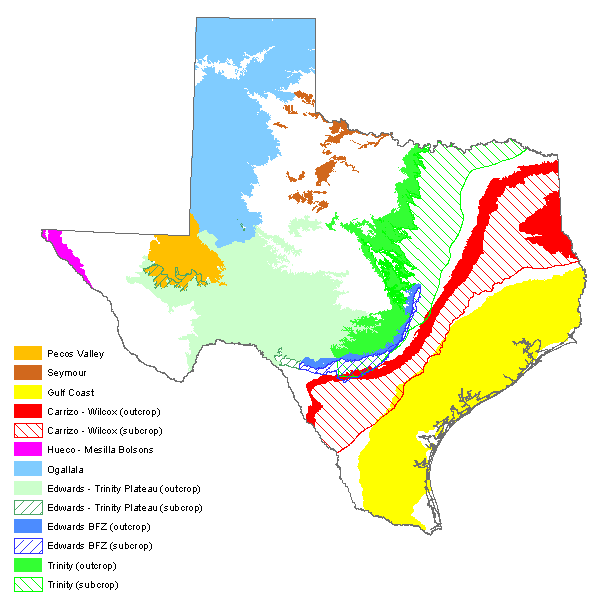
Texas has nine major aquifers and twenty-two minor ones, as classified by the Texas Water Development Board. People live on top of one of them in nearly every county of the state. Most don’t know which one. Most don’t think about the question until the well runs dry, the spring stops flowing, or the foundation starts to slip.
The state was built on water nobody can see. Roughly two and a half million people in South Central Texas now draw drinking water from a single aquifer beneath San Antonio. Tens of millions farm on the High Plains above another that, in places, took thousands of years to fill. Houston floats on a third that has been compressing for a century under the weight of its own withdrawal. Every one of these systems is finite. Every one of them is currently being asked to do more than it can.
Water shaped where Texans built. So did the topography that water carved. Springs put cities where the cities went. Rivers cut the routes that wagon trails and roads later followed. Most of the state’s geography of habitation, all the way back to the Spanish missions, maps back to the places where water came up of its own accord and the land made it possible to settle nearby. San Antonio, Austin, Boerne, Fort Stockton, Balmorhea. All of them are where they are because of an aquifer and a path the land allowed.
Rule of capture, surface water, and why the underwriting questions converge
There is one legal framework that ties all of Texas’s aquifers together, and it is Texas-specific: the rule of capture.
Under the rule of capture, the landowner above an aquifer owns the groundwater beneath that land and may pump as much of it as can be put to beneficial use, regardless of the effect on neighboring wells or on the aquifer as a whole. The Texas Supreme Court adopted the rule in 1904 in Houston & Texas Central Railway Co. v. East, and the legislature reaffirmed it in 2011 with statutory language declaring that “a landowner owns the groundwater below the surface of the landowner’s land as real property.” The 2012 Edwards Aquifer Authority v. Day decision strengthened the property interpretation further, affirming that the landowner’s ownership interest is constitutionally protected.
The practical effect of the rule of capture is that the only meaningful constraint on pumping at the parcel level is whatever the local groundwater conservation district has authority to impose. Districts vary widely. Some have aggressive permitting regimes; others have limited authority. The exception within the system is the Edwards Aquifer Authority, which operates under unique statutory authority that allows it to issue and ration permits across the Edwards (BFZ). That is why Stage 5 restrictions exist as a regulatory category in the first place.
Surface water in Texas is governed by an entirely different framework. It belongs to the state, and the right to use it is allocated by the Texas Commission on Environmental Quality under the doctrine of prior appropriation: first in time, first in right. A riparian property does not automatically have a right to take water from a creek or river that crosses it. That right has to be perfected through an appropriation certificate, and senior certificates take precedence over junior ones in drought. Two adjacent ranches with identical river frontage can have very different water rights depending on the appropriation history.
This bifurcation is the legal architecture inside which every Texas land transaction sits, whether the parties know it or not. Groundwater is a private property right under the rule of capture. Surface water is a state-administered allocation under prior appropriation. The exception matters: if groundwater is determined to be an underflow of a surface watercourse, it falls under the prior appropriation regime rather than the rule of capture.
Five different aquifers, one common legal substrate, and a regulatory environment that is shifting across all of them. The Ogallala is being mined. The Edwards is being permit-rationed. The Trinity is being drilled deeper. The Carrizo-Wilcox is being litigated over an export proposal that did not seem possible eighteen months ago. The Gulf Coast is being managed through the longest-running groundwater conversion regime in the state. None of these systems is in equilibrium.
The five major aquifers that do most of the work
Texas has nine major aquifers, but five of them carry the load: the Ogallala in the Panhandle, the Edwards Balcones Fault Zone in Central Texas, the Trinity across the Hill Country and North Texas, the Carrizo-Wilcox curving from the Rio Grande through East Texas, and the Gulf Coast system that supports the Houston metro and the upper coast. The four others (Edwards-Trinity Plateau, Pecos Valley, Hueco-Mesilla Bolsons, and Seymour) matter regionally but cover narrower geographies and serve smaller populations.
Ogallala. The High Plains
A 2025 University of Texas projection estimated that up to seventy percent of the Texas Panhandle’s Ogallala will be effectively unusable within twenty years at current rates of withdrawal. That is the most consequential single sentence about the future of Texas agriculture currently in print.
The Ogallala runs under eight states. The Texas portion sits below the Panhandle and the western edge of the Rolling Plains. It is the country’s most heavily pumped aquifer and the foundation of modern American agriculture across the High Plains.
The Ogallala was charged over millions of years from the runoff of an ancestral mountain range that no longer exists. The water in it is, in practical terms, finite. Recharge from rainfall is essentially zero in most of the Texas portion. What comes down evaporates or is taken up by crops before it reaches the water table. What’s in the aquifer is, for human-timescale purposes, what’s there.
Saturated thickness (the vertical distance from the water table to the base of the aquifer) varies dramatically across the Texas portion. The Texas Water Development Board reports a range from a few feet at the southern margin to more than 525 feet in the deepest sections, with a freshwater average of roughly 95 feet statewide. The North Plains Groundwater Conservation District, which covers the deepest part, reports a district average closer to 180 feet. The Panhandle has been pulling water from this stock at roughly six times the rate of natural recharge for decades. Saturated thickness has declined more than seventy feet in some Texas counties since the wells went in.
The implication for land in the Panhandle is structural. Cropland value has historically been a function of irrigation. Irrigation is a function of pumpable groundwater. When the pumpable groundwater is gone, the land does not stop being land. It stops being cropland. It becomes grazing land, or it becomes dryland, and both reset the value substantially.
Edwards Balcones Fault Zone. Central Texas
In May 2025, the Edwards Aquifer Authority declared Stage 5 drought restrictions for the first time in the system’s history. Stage 5 triggers the deepest pumping cuts the Authority is empowered to impose on its permit holders. The trigger was the level of the J-17 index well, the Bexar County monitoring well that has been the official benchmark for the aquifer since 1932, dropping to 624 feet. The all-time low is 612.
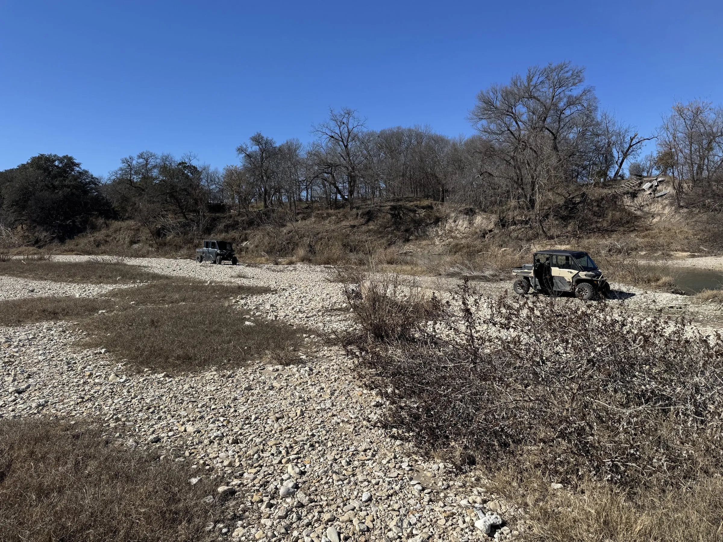
The Edwards is a karst limestone aquifer pinned between two impermeable layers along the Balcones Fault Zone. Water enters through a recharge zone in the Hill Country, gravity carries it deep, and the system pressurizes. Where a fault line cracks the cap, water moves up. The historic San Antonio artesian wells came from that pressure. So did Comal Springs (the largest in Texas), San Marcos Springs, Barton Springs, San Solomon Springs at Balmorhea, and the Edwards-fed flow that built the Guadalupe and San Marcos River systems.
The mechanism is what a hydrology textbook calls confined-aquifer artesian pressure. The diagram below shows the geometry that gives San Antonio its springs and its history of flowing wells.
Approximately two and a half million people in South Central Texas now draw drinking water from the Edwards, according to the Edwards Aquifer Authority. So do Comal Springs, San Marcos Springs, and Barton Springs.
The springs feel the level first. In late 2024, Comal Springs, the largest in Texas, was flowing at 71 cubic feet per second against a long-term average of 284. That is a 75 percent decline from baseline. San Marcos Springs was running at 83 cfs. Jacob’s Well, which drops 140 feet into one of the longest underwater cave systems in Texas, has stopped flowing in recent summers in part because a local water provider has been pulling roughly twice its permitted volume from the recharge feature that feeds it.
What pumping does to an aquifer at the local scale is captured by a concept called the cone of depression. When a well pulls water faster than the surrounding aquifer can equilibrate, the water table around the well draws down into the shape of an inverted cone. The cone is largest where the pumping is heaviest and widest where the aquifer is thinnest or least transmissive. Cones from adjacent high-volume wells overlap and compound. The diagram below shows the geometry.
For property anywhere across the Edwards’ recharge, contributing, or artesian zones (a band that runs from Uvalde through San Antonio, Comal, Hays, Travis, and Williamson counties), the water layer is rarely just about whether a well will pump. It is about which formation the well draws from, what the long-term yield trajectory looks like under current pumping pressure, and whether the live water on the property is perennial, intermittent, or seasonal, with flow data and not adjectives behind the answer.
Trinity. The Hill Country and beyond
The Trinity is the aquifer most Hill Country buyers actually drink from. The Edwards gets the headlines because of San Antonio. The Trinity gets the well bills.
It is a sandstone and limestone system spread across the western Hill Country, North Texas, and into Central Texas. Yields are notoriously variable. Well productivity in the same section can swing dramatically over short distances because the Trinity’s water moves through fractures and dissolution features, not a uniform pore network. Two adjacent properties can have very different well economics. This is a function of the geology, not the drilling contractor.
The Trinity is also one of several Texas aquifers that sits beneath another. The Edwards (BFZ) is stratigraphically above the Trinity across much of the Hill Country. That stacking matters because aquifers don’t operate in isolation. Pumping from one can change the recharge to another. Where the upper aquifer is dewatered, the lower one may eventually be tapped to compensate, which compounds rather than relieves the stress.
The Hill Country portion of the Trinity is now under documented strain. The Hays Trinity Groundwater Conservation District reported in March 2026 that aquifer and river conditions in its service area are the worst in the district’s twenty-plus-year history, including against the 2011 drought, the prior benchmark for severity. Wells across western Hays County are being deepened. In the small community of Radiance, a backup well went dry in 2025 and residents lived under a boil-water order for more than six months.
The more difficult fact is what is happening in the Lower Trinity. New wells in northern Hays County are being drilled into the confined Lower Trinity Aquifer, a deeper formation that, according to USGS tritium dating, has essentially no recharge on a human timescale. Roughly half of Trinity Aquifer samples in USGS surveys carry no detectable tritium at all, meaning the water has received no measurable input from precipitation since at least 1953. Some of it is dated to thousands of years before that. Pumping from the Lower Trinity is, by the data, withdrawal from a non-renewing stock.
Underwriting any Trinity-served property (Hill Country ranch, weekend home, residential subdivision lot) has to include a real question about which Trinity. The economics of a Middle Trinity well and a Lower Trinity well diverge sharply over twenty years.
There is also a separate but related concept worth surfacing here, because the Trinity’s behavior makes it concrete: baseflow. Many Texas rivers and creeks receive a significant fraction of their dry-season flow from groundwater seeping into the streambed. That’s baseflow. The Texas Water Development Board has historically estimated that roughly thirty percent of streamflow in Texas rivers is groundwater-derived, with the share rising substantially in drought conditions. When an aquifer declines, baseflow declines with it. The river goes quiet in the dry months not because rain stopped but because the aquifer that was holding it up has dropped below the streambed.
Carrizo-Wilcox. East Texas
The Carrizo-Wilcox is a band of sandstone and clay that runs in a curve from the Rio Grande through East Texas and into the Sabine River basin. It is the second most heavily pumped aquifer in the state behind the Ogallala. It supplies drinking water to a long list of East and Central Texas cities (Crockett, Van, Athens, Smith County) and it is the source for the Vista Ridge pipeline that moves roughly 16 billion gallons per year from Burleson County to San Antonio.
The Carrizo-Wilcox is the aquifer to watch for a different reason than the others. The pressure on this system is not primarily agricultural or municipal. It is acquisitive.
In 2025, Kyle Bass’s Redtown Ranch Holdings and Pine Bliss LLC filed permit applications to withdraw roughly 15.9 billion gallons per year, about 48,000 acre-feet, from the Carrizo-Wilcox in East Texas, with the stated intent to sell that water elsewhere in the state. The proposal sparked a rural opposition campaign that crossed political lines, generated state legislation, and culminated in an October 2025 district court order voiding the prior administrative-completeness ruling and prohibiting the relevant groundwater conservation district from approving any withdrawal of 3,000 acre-feet or more until the aquifer has been studied. The Texas Legislature has signaled a two-year moratorium on new large extractions.
What this means for land in the Carrizo-Wilcox region is that the regulatory environment around groundwater export is now contested in a way it was not eighteen months ago. A property whose value has been partly underwritten on the assumption of unrestricted groundwater rights (for sale, lease, or commercial pumping) is now operating in a different legal landscape than it was during its last comp set. That landscape is still being defined.
Gulf Coast. The Houston region and the upper coast
Parts of the Harris-Galveston region subsided more than ten feet over the course of the twentieth century, the literal sinking of the land, as the Gulf Coast Aquifer’s clay-rich sediments compacted under heavy groundwater withdrawal. Foundations cracked. Drainage paths reversed. Floodplain maps had to be redrawn.
The Gulf Coast Aquifer System is a stack of three units (the Chicot at the surface, the Evangeline below it, the deeper Jasper further down) that runs from the Louisiana border down through Houston and into South Texas. It is the aquifer that supplies most of the Houston metro and a significant fraction of the upper Texas coast. The diagram below shows the stacked geometry that defines the system.
There is a second consequence at the water-quality level: saltwater intrusion. Where freshwater pumping reduces the inland hydraulic head, the dense saline groundwater beneath the coast moves landward to replace the volume removed. The U.S. Geological Survey has documented salinity inversion, where higher-salinity groundwater overlies lower-salinity groundwater, in eight Texas aquifers. The Gulf Coast is among the most affected. The interaction is density-driven. Saltwater is heavier than freshwater, and when the freshwater pressure that has been holding it back is reduced, the wedge moves inland and downward.
In response to subsidence, the Harris-Galveston Subsidence District, established in 1975, instituted mandatory groundwater-to-surface-water conversions backed by escalating disincentive fees. By 2025, the District’s target is to limit groundwater use to no more than 40 percent of Texas Water Development Board allocations across most of its service area. In the most-regulated zones, measured subsidence has slowed materially or stopped.
For property in the Houston metro and the Gulf Coast, the underwriting question is rarely about the well, since most parcels are on municipal water. It is about whether the parcel sits inside or outside the regulated zone, what the historical subsidence has done to elevation relative to nearby drainage and floodplain, and what the local utility’s surface-water conversion plan looks like over the next twenty years.
The complete TWDB classification
Five aquifers do most of the work, but the full Texas Water Development Board classification lists nine major and twenty-two minor. The table below names them.
| Classification | Aquifer | Region |
|---|---|---|
| Major | Carrizo-Wilcox | South / East / Central Texas band |
| Major | Edwards (Balcones Fault Zone) | Central Texas. San Antonio, Hill Country |
| Major | Edwards-Trinity (Plateau) | West Central Texas. Edwards Plateau |
| Major | Gulf Coast | Coastal Texas. Louisiana to Mexico border |
| Major | Hueco-Mesilla Bolsons | Far West Texas. El Paso region |
| Major | Ogallala | Panhandle and South Plains |
| Major | Pecos Valley | Far West Texas. Pecos River valley |
| Major | Seymour | North Central Texas. Discontinuous patches |
| Major | Trinity | Central, North, and Hill Country |
| Plus 22 minor aquifers, including Blossom, Brazos River Alluvium, Capitan Reef Complex, Dockum, Edwards-Trinity (High Plains), Ellenburger-San Saba, Hickory, Igneous, Lipan, Marathon, Marble Falls, Nacatoch, Queen City, Rita Blanca, Rustler, Sparta, West Texas Bolsons, Woodbine, Yegua-Jackson, and others. (Texas Water Development Board) | ||
The five that carry most of the load, per this analysis.
What they have in common
The Texas Water Development Board, in the draft 2027 State Water Plan, projects that statewide water availability will decline by nine percent between 2030 and 2080, and existing supply will decline by ten percent over the same window, even after spending the $174 billion the Plan identifies as necessary investment. Texas’s population is expected to grow by 53 percent over that period. Water demand is expected to grow by 6 percent, which is the Plan’s polite way of saying that conservation, surface-water transfers, desalination, and reuse will need to absorb almost all of the additional load. The implicit assumption is that groundwater will be doing less work, not more.
The properties that depend on groundwater are not all in the same place on the curve, but they are all on the same curve. The well-water Hill Country ranch, the irrigated Panhandle section, the East Texas tract with commercial pumping rights, the Edwards-fed live-water creek that runs in the wet years. The curve is heading the same direction.
What this means when you’re underwriting Texas land
Water is one of the six layers in any serious site analysis. For the kind of properties where it matters, and that includes most rural and transitional Texas land outside the Houston metro, the water layer is rarely a single question. It is a sequence.
Which aquifer underlies the property? Which formation within that aquifer is the well drawing from, and is a deeper, less-renewing formation in play if the shallower one is failing? What is the trend on the relevant index well over five years, ten years, twenty? What is the local groundwater conservation district doing with its permitting authority, and is the political composition of its board stable? If there is live water on the property, what does the flow data show across a representative drought cycle, not just on the day of the property tour? If there is a spring, is it spring-fed from a perennial source or seep-fed from a shallow water table that can disappear in a dry year? If there are surface water rights, what is the priority date on the appropriation certificate, and where does it sit in the local seniority order during a drought call?
A property valued partly on its spring or its creek carries a meaningful exposure if that surface water depends on aquifer levels that are now structurally lower than they were when the comp set was assembled, because the baseflow that holds the stream up in the dry months is itself a function of the underlying aquifer. A property valued entirely on its well productivity carries a different exposure if the underlying formation is being pumped beyond recharge by a regional water provider operating under a permit that may or may not survive the next district board cycle. A property valued partly on its development potential carries a third exposure if the relevant aquifer is now under a moratorium that did not exist when the planning department issued the original conceptual approval.
None of this means the land isn’t worth buying. It means the value the buyer thinks they are buying is partly a function of an underlying system that the listing agent is rarely positioned to explain.
The honest read
The questions are not difficult to ask. They are unfamiliar to most of the people writing the contracts, which is different. They are also the questions that decide whether the value the buyer thinks they are buying will still be there in twenty years.
The pressure that built this state is being tested across all five major aquifers at once. The artesian pressure that put cities where the springs came up. The irrigation pressure that turned the Panhandle into a grain belt. The municipal pressure that lets four metropolitan areas grow as fast as they do. The state is not running out of water tomorrow. It is restructuring around water in a way that most land valuations have not yet absorbed.
The properties that hold their value through the restructuring are the ones whose owners understood the layer they were buying.
B. Bailey Land Advisors includes water and aquifer analysis in every property evaluation. To discuss a specific property, reach out.
Where the value begins.
Sources · click to expand
Texas Water Development Board (primary)
- Texas Aquifers (overview). TWDB classification of nine major and twenty-two minor aquifers
- Major Aquifers
- Minor Aquifers
- Ogallala Aquifer (TWDB). Saturated thickness data
- Gulf Coast Aquifer (TWDB)
- Aquifers of Texas, TWDB Report 345
- Study of Brackish Aquifers in Texas, Project #1 Gulf Coast (TWDB)
- What Should Texas Do About the Rule of Capture? Corwin W. Johnson, TWDB Report 361, Chapter 2
Edwards Aquifer Authority (primary)
- Edwards Aquifer Authority homepage. Population served, drought stages
- EAA Fact Sheet 2023
- What is the Aquifer? EAA 2025 revision
Harris-Galveston Subsidence District (primary)
Hays Trinity Groundwater Conservation District / USGS / academic
- Hydrology of the Texas Gulf Coast aquifer systems, USGS
- Liquid Assets: Groundwater in Texas, Yale Law Journal
- Understanding Groundwater Law, Texas Water Resources Institute, Texas A&M
- North Plains Groundwater Conservation District, Ogallala
- Texas Handbook, Artesian Wells
News coverage (secondary, used where primary sources do not yet exist)
- Texas needs at least $174 billion to avoid water crisis, Texas Tribune, April 2026 (draft 2027 State Water Plan)
- Edwards Aquifer reaches lowest level since 1990, KSAT, April 2025
- San Antonio’s Edwards Aquifer nears lowest level ever, Stage 5 declared, Texas Public Radio, May 2025
- Hays County wells run drier as aquifers fall to their lowest levels in more than 20 years, KUT, March 2026
- Texas House approves bill that would limit water exports from East Texas, Texas Tribune, August 2025
- Plan to pump billions of gallons of water from East Texas on hold, Texas Tribune, October 2025
By Bryan E. Bailey